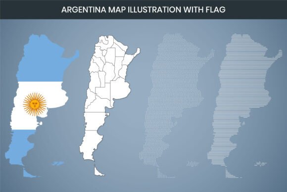
Argentina Map Illustration with Flag
A map of Argentina combined with its national flag is a distinct visual asset that serves far more than decorative purposes. This specific illustration, built with a 3000 x 2000 pixel dimension at 300 DPI resolution, bridges the gap between high-end graphic design and practical accessibility. What makes this particular asset stand out is the range of file formats included—AI, SVG, EPS, DXF, PNG, and PDF—along with full editability, including a Canva editable version. Whether you need a polished graphic for a client presentation, a cut file for a woodworking project, or a clear map for a classroom handout, the value of this illustration depends heavily on how its technical features align with your specific workflow.
For Digital Creators and Social Media Marketers
Speed and visual quality often dictate the tools a content creator uses. The PNG file format, provided in standard RGB color mode, is immediately ready for use in blogs, website headers, or social media graphics. The 3000 x 2000 pixel dimension ensures the map remains sharp across large displays, while the 300 DPI resolution guarantees clear rendering even if the image is scaled down for thumbnails or profile pictures.
The inclusion of a Canva editable file is a significant time-saver for marketing teams or solo bloggers who may not have access to Adobe software. You can drop this map directly into a Canva template, overlay text for a blog post about Argentinian wine regions, or adjust the opacity to create a subtle background graphic. For a freelance writer covering Latin American geopolitics, having a royalty-free vector map Argentina that is easy to customize means spending less time searching for visuals and more time on research. The editable nature allows you to maintain brand consistency across different campaigns without needing a graphic design degree.
Educators, Trainers, and Data Analysts
Accuracy and clarity are non-negotiable in educational materials. An Argentina map illustration with flag can be easily adapted into a political map or a data visualization infographic. The vector formats—AI, SVG, and EPS—allow educators to strip away the flag colors entirely, focusing solely on the geographic outline or provincial boundaries. This flexibility makes it easy to create custom labeling exercises or highlight specific regions for a geography lesson.
For an analyst preparing a report on regional economic data, the editable file supports detailed manipulation. You can segment the country into distinct color-coded zones, add legends, and export the final product as a Print Ready PDF. The high resolution (300 DPI) ensures that even when printing at large poster sizes, the text and borders remain crisp and professional. The map becomes a reliable foundation for building complex infographics without starting from scratch. Having the flag integrated means the visual identity of the country is immediately recognizable, which is valuable for international reports or presentations.
Small Business Owners and Entrepreneurs
For businesses targeting the Argentine market or celebrating Argentine heritage, this map offers strong commercial potential. The Print Ready PDF file is ideal for creating physical marketing materials like brochures, flyers, or menu covers. The PNG file works seamlessly on digital storefronts, social media ads, or email newsletters.
The DXF laser cut design format opens a unique revenue stream for entrepreneurs involved in physical goods. A small business specializing in custom decor can take this file and produce layered wooden maps, acrylic signs, or engraved coasters featuring the Argentinian flag. The laser cut design is specifically optimized for this purpose, meaning the vector paths are clean and ready for cutting software. This transforms a simple digital illustration into a tangible product with high perceived value. Using a royalty-free map Argentina keeps overhead low while allowing for a premium finished product.
Hobbyists and DIY Makers
The DIY community, particularly those involved in laser cutting and vinyl crafting, will find the DXF and SVG formats essential. The term "laser cut design" indicates that the file has been prepared with clean, enclosed paths suitable for cutting tools. A hobbyist can easily import the SVG file into their preferred crafting software—whether for a Cricut, Silhouette, or a full-sized laser cutter—and produce a beautifully layered flag map.
This project could range from a wall art piece for a home office to a personalized gift for someone with ties to Argentina. The 300 DPI resolution is also beneficial here; while cut lines rely on vector math, the PNG file can be used for printed inserts or as a reference layer. For a maker, this asset saves hours of manual tracing or file cleanup. Instead of converting a low-quality JPEG, you start with a clean, scalable vector that is ready for fabrication. The flexibility to scale the map for a small keychain or a large wall hanging without losing detail makes it a versatile addition to any crafting library.
Professional Designers and Creative Agencies
For seasoned designers, the primary value lies in the completeness and reliability of the file package. Having access to AI, SVG, EPS, and PDF formats ensures that the Argentina map illustration with flag integrates seamlessly into any existing workflow. Whether you are building a complex layout in InDesign, creating a motion graphic in After Effects, or designing a web icon in Figma, the correct vector format is readily available.
The large 3000 x 2000 pixel canvas provides ample room to extract specific regions, such as Patagonia or the Buenos Aires area, without losing resolution. The fully editable nature of the file means you are not stuck with a flat image. You can ungroup elements, recolor individual paths, adjust the flag pattern, or combine the map with other graphics. For a designer working on a tight deadline, starting with a clean, well-structured vector file reduces production time significantly. The assurance of a Print Ready PDF also helps when delivering final assets to clients who may require hard copies. This asset acts as a reliable foundation for professional-grade projects, from annual reports to large-format trade show displays.
How to Determine If This Map Fits Your Project
Choosing the right asset comes down to evaluating your specific needs against the file's capabilities. Here is a practical framework to guide your decision:
- Ease of Use: If you are a beginner or need a fast solution, start with the Canva editable file or the high-res PNG. These require minimal technical knowledge and deliver professional results immediately.
- Customization and Flexibility: If you plan to heavily modify the map—change colors, add data points, or extract specific provinces—use the AI or SVG formats. These vector files give you complete control over every element.
- Print Quality: For any physical output, rely on the Print Ready PDF or the 300 DPI PNG. These formats preserve the sharpness and color accuracy needed for brochures, posters, or large-format prints.
- Physical Fabrication: If you intend to cut the map out of wood, acrylic, or vinyl, the DXF file is your best option. Ensure your cutting software supports this format for a smooth experience.
- Long-Term Usability: Consider the royalty-free nature of the asset. Having a versatile vector file means you can repurpose it for different clients, campaigns, or personal projects without additional costs.
An Argentina map illustration with flag is a multifaceted tool, not just a single image. The thought put into the file formats and resolution standards means it can serve a wide spectrum of users, from a student learning geography to a professional designer creating a national brand campaign.
The true strength of this asset lies in its adaptability. By understanding the strengths of each included format—whether it is the editability of the AI file, the compatibility of the SVG, the precision of the DXF, or the immediacy of the PNG—you can select the right tool for your specific task. This ensures that the final output, whether digital or physical, accurately reflects the quality and intent of your project.